START Network
This collection of maps provides climate forecast information on seasonal and subseasonal timescales to support decision-making by humanitarian aid agencies in the START NetworkClick the tabs (top right) for links to the following useful maps:
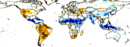
- Subseasonal Forecasts: The 1st Maproom (Precipitation Tercile Probability Forecast) proposes experimental subseasonal forecasts of 2-week precipitation terciles through a rigorous calibration methodology. Other Maprooms were experiment on how to show where heavy rainfall or unusually warm or cold conditions may occur over the next four weeks, prior to the existence of the calibrated forecast.
- Three-Month Forecasts: These maps show where large or small amounts of rainfall are expected in the next three months.
- Country Pages: These pages provide additional information relevant to the START Network hub countries.


//bbox/parameter/geoobject/geoboundingbox/BOXEDGES/X/Y/fig%3A/colors/black/coasts_gaz/countries_gaz/%3Afig//plotborder/0/psdef//plotaxislength/220/psdef/(antialias)/true/psdef//Spearman/-1.0/1.0/plotrange//T/0.5/plotvalue/+.gif)